Warning: Lfh_Model_Map::set_default(): Argument #3 ($args) must be passed by reference, value given in
/home/clients/d4b621ad8ff4281e59784597b6891d65/web/wp-content/plugins/lf-hiker/Model/Map.php on line
229
Warning: Lfh_Model_Map::set_default(): Argument #3 ($args) must be passed by reference, value given in
/home/clients/d4b621ad8ff4281e59784597b6891d65/web/wp-content/plugins/lf-hiker/Model/Map.php on line
229
Warning: Lfh_Model_Map::set_default(): Argument #3 ($args) must be passed by reference, value given in
/home/clients/d4b621ad8ff4281e59784597b6891d65/web/wp-content/plugins/lf-hiker/Model/Map.php on line
229
Warning: Lfh_Model_Map::set_default(): Argument #3 ($args) must be passed by reference, value given in
/home/clients/d4b621ad8ff4281e59784597b6891d65/web/wp-content/plugins/lf-hiker/Model/Map.php on line
229
Warning: Lfh_Model_Map::set_default(): Argument #3 ($args) must be passed by reference, value given in
/home/clients/d4b621ad8ff4281e59784597b6891d65/web/wp-content/plugins/lf-hiker/Model/Map.php on line
229
Warning: Lfh_Model_Map::set_default(): Argument #3 ($args) must be passed by reference, value given in
/home/clients/d4b621ad8ff4281e59784597b6891d65/web/wp-content/plugins/lf-hiker/Model/Map.php on line
229
Warning: Lfh_Model_Map::set_default(): Argument #3 ($args) must be passed by reference, value given in
/home/clients/d4b621ad8ff4281e59784597b6891d65/web/wp-content/plugins/lf-hiker/Model/Map.php on line
229
Warning: Lfh_Model_Map::set_default(): Argument #3 ($args) must be passed by reference, value given in
/home/clients/d4b621ad8ff4281e59784597b6891d65/web/wp-content/plugins/lf-hiker/Model/Map.php on line
229
Warning: Lfh_Model_Map::set_default(): Argument #3 ($args) must be passed by reference, value given in
/home/clients/d4b621ad8ff4281e59784597b6891d65/web/wp-content/plugins/lf-hiker/Model/Map.php on line
229
Warning: Lfh_Model_Map::set_default(): Argument #3 ($args) must be passed by reference, value given in
/home/clients/d4b621ad8ff4281e59784597b6891d65/web/wp-content/plugins/lf-hiker/Model/Map.php on line
229
Warning: Lfh_Model_Map::set_default(): Argument #3 ($args) must be passed by reference, value given in
/home/clients/d4b621ad8ff4281e59784597b6891d65/web/wp-content/plugins/lf-hiker/Model/Map.php on line
229
Warning: Lfh_Model_Map::set_default(): Argument #3 ($args) must be passed by reference, value given in
/home/clients/d4b621ad8ff4281e59784597b6891d65/web/wp-content/plugins/lf-hiker/Model/Map.php on line
229
Warning: Lfh_Model_Map::set_default(): Argument #3 ($args) must be passed by reference, value given in
/home/clients/d4b621ad8ff4281e59784597b6891d65/web/wp-content/plugins/lf-hiker/Model/Map.php on line
229
Warning: Lfh_Model_Map::set_default(): Argument #3 ($args) must be passed by reference, value given in
/home/clients/d4b621ad8ff4281e59784597b6891d65/web/wp-content/plugins/lf-hiker/Model/Map.php on line
229
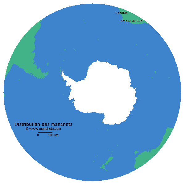
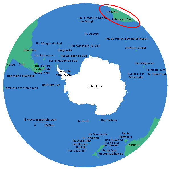
 Le manchot du Cap, seul manchot visible en Namibie, est présent sur 8 îles et sur 2 emplacements de la côte.
La population a fortement baissé. Elle n’était estimée qu’à 3 400 couples en 2006. Alors qu’en 1956, ce chiffre était de 42 000 couples puis de 12 000 en 1978.
Points d’observation
Les points d’observations sont:
- Mercury island : la plus grande colonie de manchots en Namibie mais sa population décroit de 3,7% par an
- Neglectus islet : colonie partagée avec le cormoran des bancs
- Ichaboe island : 2ème colonie de manchots en Namibie, sa population décroit aussi régulièrement.
- Halifax island : 3ème colonie de manchots en Namibie, la seule dont la population augmente.
- Possession island : 4ème colonie de manchots en Namibie, elle était la plus grande colonie avec 46 000 manchots. En 2006, ils n’étaient plus que 1 400.
- Albatross rock : quelques manchots y nidifient pour de courtes durées
- Pomona island
- Plumpudding and Sinclair islands : petite colonie mais importante de par sa position, c’est la plus méridionale et elle fait le ‘lien’ avec les populations de manchots d’Afrique du Sud.
- Sur la côte entre Meob bay et Sylvia Hill : la présence de manchots la plus septentrionale
- Cape Cross: en de rares occasions, à cause de l’imposante colonie d’otaries à fourrure
Penguin islands fait référence à un groupe d’île comprises entre Little Roastbeed islets (au sud) et Hollam’s Bird island (au nord). Sur l’île dite Penguin island, très peu de manchots voire aucun.
Cliquez sur le bouton suivant ou l′élément sur la carte pour voir ses informations
Mercury island
Latitude:
-25° 43' 08"
Longitude:
14° 49' 58"
Neglectus islet
Latitude:
-26° 08' 11"
Longitude:
14° 56' 45"
Ichaboe island
Latitude:
-26° 17' 20"
Longitude:
14° 56' 10"
Halifax island
Latitude:
-27° 07' 07"
Longitude:
15° 14' 16"
Possession island
Latitude:
-27° 00' 44"
Longitude:
15° 11' 36"
Albatross rock
Latitude:
-27° 07' 07"
Longitude:
15° 14' 16"
Pomona island
Latitude:
-27° 11' 36"
Longitude:
15° 15' 27"
Plumpudding island
Latitude:
-27° 38' 29"
Longitude:
15° 30' 48"
Sinclair island
Latitude:
-27° 39' 54"
Longitude:
15° 31' 12"
Meob bay
Latitude:
-24° 31' 09"
Longitude:
14° 36' 48"
Entre Meob bay et Sylvia Hill
Sylvia Hill
Latitude:
-25° 08' 57"
Longitude:
14° 51' 16"
Entre Meob bay et Sylvia Hill
Cape Cross
Latitude:
-21° 46' 18"
Longitude:
13° 57' 08"
Hollams Bird island
Latitude:
-24° 38' 20"
Longitude:
14° 31' 52"
Île la plus septentrionale des Penguin islands
Little Roastbeef islets
Latitude:
-27° 42' 01"
Longitude:
15° 31' 43"
Île la plus méridionale des Penguin islands
Penguin island
Latitude:
-26° 37' 0000"
Longitude:
15° 09' 15"
Malgré son nom, pas de manchot.
Manchots
En savoir plus
Liens